Plik:Austria Hungary ethnic.svg
Z Nonsensopedii, polskiej encyklopedii humoru

Wielkość pliku podglądu PNG dla pliku SVG: 775 × 599 pikseli Inne rozdzielczości: 310 × 240 pikseli • 621 × 480 pikseli • 993 × 768 pikseli • 1280 × 990 pikseli • 2560 × 1980 pikseli • 1360 × 1052 pikseli.
Rozmiar pierwotny (Plik SVG, nominalnie 1360 × 1052 pikseli, rozmiar pliku: 1,56 MB)
Opis
| Opis |
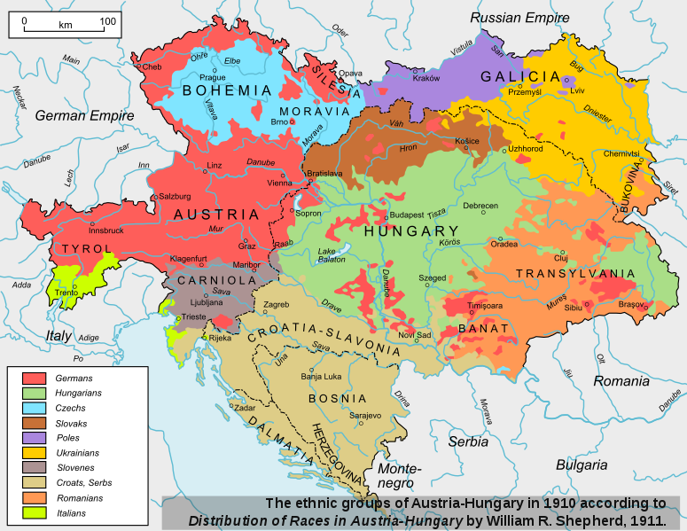
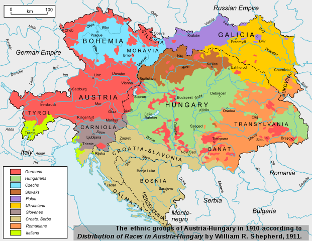
English: The ethnic groups of Austria-Hungary in 1910. Based on "Distribution of Races in Austria-Hungary" from the Historical Atlas by William R. Shepherd, 1911, File:Austria_hungary_1911.jpg. The city names were changed to those in use since 1945. |
||
| Data | |||
| Źródło | Na Commons przeniesiono z en.wikipedia. | ||
| Autor | ArdadN | ||
| Licencja (Ponowne użycie tego pliku) |
|
||
| Inne wersje |
[]
|
||
| SVG rozwój | Kod źródłowy tego pliku SVG jest niepoprawny z powodu błędu. Ta niezgodna z W3C mapa została stworzona za pomocą Inkscape |


.svg)


Oryginalny rejestr przesyłania
The original description page is/was here. All following user names refer to en.wikipedia.
- 00:58, December 22, 2008 ArdadN 1,360×1,052 (1.6 MB)
- 00:57, December 22, 2008 ArdadN 1,360×1,052 (1.5 MB) Own work.
Historia pliku
Kliknij na data/czas by zobaczyć, jak plik wyglądał we wcześniejszych wersjach.
| Data i czas | Miniatura | Wymiary | Autor | Opis | |
|---|---|---|---|---|---|
| aktualne | 22:00, 17 lip 2013 | | 1360 × 1052 (1,56 MB) | wikimediacommons>Praxis Icosahedron | Improved fonts |
Wykorzystanie linków do pliku
Poniższa strona korzysta z tego pliku:
