Plik:COVID-19 Outbreak World Map.svg

Rozmiar pierwotny (Plik SVG, nominalnie 2921 × 1500 pikseli, rozmiar pliku: 1,72 MB)

|
This file may be updated to reflect new information. If you wish to use a specific version of the file without new updates being mirrored, please upload the required version as a separate file. |
Opis
| Opis |
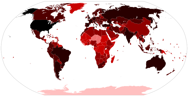
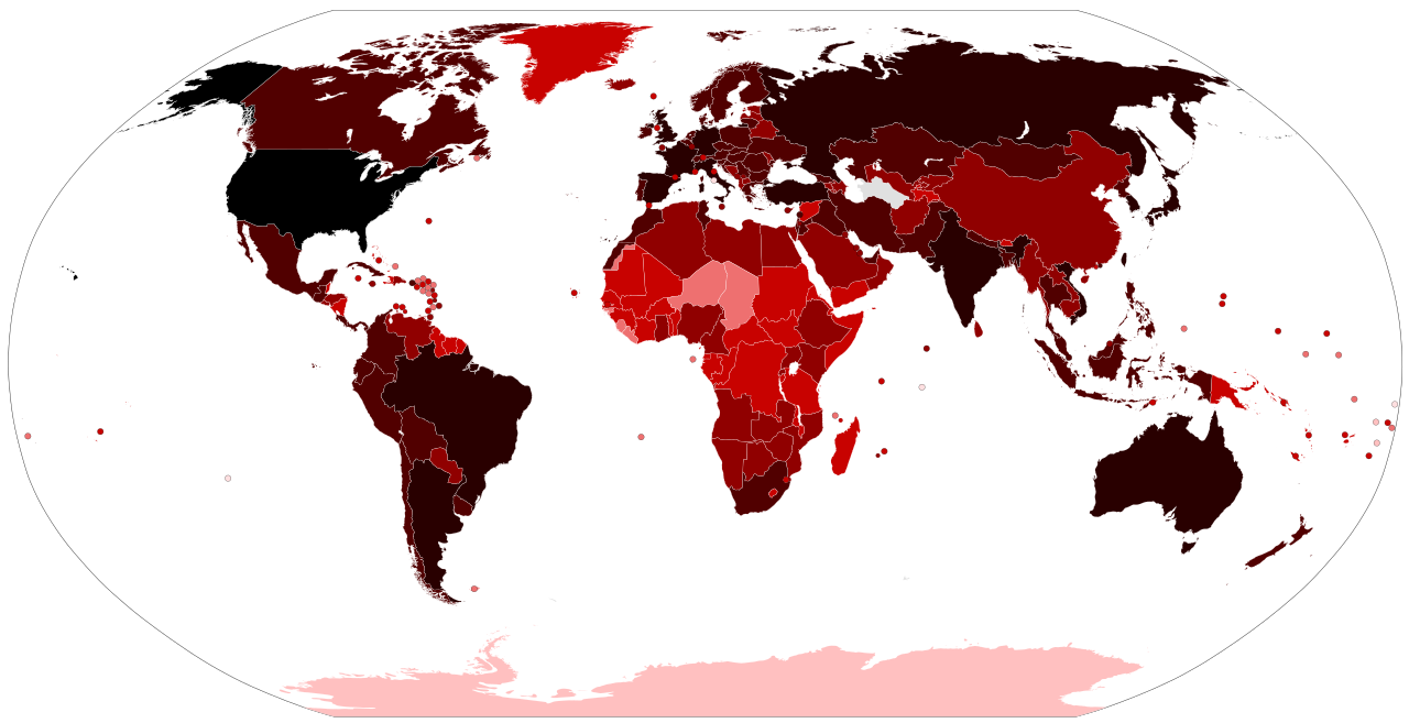
Map of the COVID-19 outbreak. Total cumulative confirmed COVID-19 cases by country. See the file history farther down for the latest upload date. Be aware that since this is a rapidly evolving situation, new cases may not be immediately represented visually. Refer to the primary article COVID-19 pandemic or the World Health Organization's situation reports for most recent reported case information. Legend information: 100,000,000+ Confirmed cases #290000 #510000 #900000 #c80200 #ee7070 #ffC0C0 #ffdfe0 #e0e0e0 No |
| Data |
– Date of first upload to the Wikimedia Commons. See the file history farther down for the latest upload date. Update the "point in time" date in the Wikidata entry linked below. {{wikidata|property|Q101240885|P585}} is used in map captions on Wikipedia. It provides the map date. To enable the date change click the purge link after updating the Wikidata entry. |
| Źródło |
Latest versions: https://ourworldindata.org/explorers/coronavirus-data-explorer?tab=map&Metric=Confirmed+cases&Interval=Cumulative&Relative+to+Population=false&Align+outbreaks=false&country=~OWID_WRL - Our World in Data. Click on the download tab to download map. The table tab has a table of the exact data by country. Source tab says data is from the COVID-19 Data Repository by the Center for Systems Science and Engineering (CSSE) at Johns Hopkins University. The map at the source is interactive and provides much more detail. For example, run your cursor over the color bar legend to see the countries that apply to that point in the legend.
|
| Autor |
Various Commons editors. See file history for latest ones. Older versions: Svenskbygderna (original author); Ratherous, AKS471883 (contributors); authors of File:BlankMap-World.svg (source file) |
| Inne wersje |
|
| SVG rozwój | Kod źródłowy tego pliku SVG jest niepoprawny z powodu błędu. Ta niezgodna z W3C mapa została stworzona za pomocą Inkscape. |


Licencja
- Wolno:
- dzielić się – kopiować, rozpowszechniać, odtwarzać i wykonywać utwór
- modyfikować – tworzyć utwory zależne
- Na następujących warunkach:
- uznanie autorstwa – musisz określić autorstwo utworu, podać link do licencji, a także wskazać czy utwór został zmieniony. Możesz to zrobić w każdy rozsądny sposób, o ile nie będzie to sugerować, że licencjodawca popiera Ciebie lub Twoje użycie utworu.
Historia pliku
Kliknij na data/czas by zobaczyć, jak plik wyglądał we wcześniejszych wersjach.
| Data i czas | Miniatura | Wymiary | Autor | Opis | |
|---|---|---|---|---|---|
| aktualne | 16:21, 14 cze 2023 | | 2921 × 1500 (1,72 MB) | wikimediacommons>AKS471883 | Macao 10000 |
Wykorzystanie linków do pliku
Poniższa strona korzysta z tego pliku:
